notes.husk.org/likes
images.
similar to
151613053304
.
24 images, most alike first.
8 images
aerial view
satellite imagery
industrial landscape
agricultural fields
shipping containers
evaporation ponds
salt pans
geometric pattern
landscape
Notational
6 images
aerial view
satellite imagery
salt evaporation ponds
salt flats
abstract patterns
landscape
earth tones
salt pans
top-down view
mineral deposits
hyperreal cartography & the unrealized city
constant
constant nieuwenhuys
new babylon
urbanism
architecture
situationism
LESS IS MORE
6 images
satellite imagery
google earth
aerial view
geography
cartography
topography
map view
landscapes
urban areas
Notational
aerial view
cityscape
urban planning
radial design
geometric pattern
top-down view
street layout
architecture
city grid
Daily Overview
aerial view
satellite imagery
agricultural land
water basin
geometrical pattern
canal
agriculture
topography
rural scenery
landscape
Dan W, Software Developer
2 images
aerial view
satellite imagery
evaporation ponds
salt pans
mineral extraction
arid landscape
desert
topography
pattern
Dan W, Software Developer
aerial view
satellite imagery
evaporation ponds
salt flats
desert
mineral extraction
pattern
top-down view
lithium mining
Dan W, Software Developer
4 images
solar farm
solar panels
desert
aerial view
renewable energy
solar array
satellite imagery
geometric pattern
solar energy
clean energy
STML
aerial view
satellite imagery
industrial landscape
evaporation ponds
salt mine
magenta ponds
top-down view
abstract landscape
mining facility
patterned terrain
Daily Overview
aerial view
landscape
airplane shadow
power plant
cooling towers
industrial landscape
river
agriculture
surrealism
concept art
Dan W, Software Developer
river
desert
farm
cartography
maps and atlases
fav
manmade
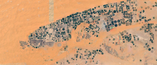
Satellite Delight
aerial view
satellite imagery
center-pivot irrigation
agriculture
arid landscape
irrigation patterns
crop fields
desert agriculture
The New Aesthetic
3 images
farms
farm life
saudi arabia
desert
orange
man made
Satellite Delight
glitch art
abstract
digital art
fragmented
geometric pattern
deconstructed landscape
texture
earthy tones
modern art
STML
aerial view
satellite imagery
evaporation ponds
salt pans
desert
aquaculture
reservoir
top-down view
arid environment
geometric
Daily Overview
solar panels
solar farms
solar farm
europe
why not usa?
manmade
Satellite Delight
urban planning
landscape architecture
master plan
site plan
aerial view
green infrastructure
waterfront development
cityscape
urban regeneration
Tecznts
aerial view
satellite imagery
coastal city
airport runway
port
cityscape
top-down view
coastline
urban planning
Daily Overview
aerial view
waterfront living
canal community
suburban landscape
urban planning
residential area
top-down view
waterways
geometric pattern
Daily Overview
cartography
urban planning
topography
collage
aerial view
minimalism
data visualization
graphic design
geography
Dan W, Software Developer
airplane
satellite image
maps and atlases
glitch
architecture
manmade
Satellite Delight
aerial view
satellite imagery
evaporation ponds
lithium mining
salt flats
desert
red earth
top-down view
mineral extraction
geometric pattern
Daily Overview
solar energy
renewable energy
concentrated solar power
desert
aerial view
solar thermal plant
sustainability
clean energy
heliostats
solar farm
Notational