notes.husk.org/likes
images.
tagged geography.
page 1 of 4 with 75 images.
united states map
data visualization
infographic
urban atlas
metropolitan areas
cartography
geography
us cities
statistical data
minimalist design
Tecznts
london
urban development
data visualization
cartography
urban planning
geography
built environment
mapping
spatial analysis
urban change
psd
topographic map
historical map
vintage map
california
los angeles
cartography
usgs
geography
antique map
san fernando valley
BATTERED SHOES
map making
grid
checkerboard
topographic map
geography
nemfrog
1864
19th century
nemfrog
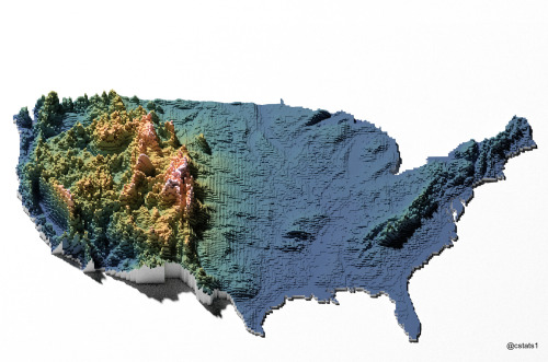
3d map
united states
topography
voxel art
data visualization
geography
digital art
terrain
elevation
usa
Our Melancholy Menagerie
google maps
iceland
mapping
geography
technology
comparison slider
topography
digital cartography
landscape
web design
koanstudy
3 images
map
cartography
data visualization
night mode map
digital map
urban map
street map
geography
dark aesthetic
gis visualization
The New Aesthetic
map
united states
usa
topographic map
road map
geography
cartography
north america
wall art
highways
Notational
topographic map
cartography
coastline
russian river
geography
terrain
contour lines
coastal landscape
map art
landscape topography
Get The Pliars
map
california
nevada
grid overlay
data visualization
cartography
geography
topography
united states
spatial data
Tecznts
isochronic maps
travel time
london
historical comparison
transportation
world map
geography
cartography
globalization
1914 vs 2016
things magazine tumblr
collage
street view
satellite view
urban landscape
cityscape
world locations
geography
travel
map views
different cities
The New Aesthetic
vintage map
antique map
scotland
cartography
topography
physical geography
historical map
highlands
geography
united kingdom
Activator / Inhibitor
cartography
urban planning
information design
topography
digital collage
aerial view
minimalist design
data visualization
graphic design
geography
Dan W, Software Developer
world map
global coverage
data visualization
infographic
geographic distribution
map legend
cartography
coverage levels
global statistics
geography
Notational
cartography
map projection
geography
globe
diagram
educational illustration
distortion
scientific illustration
geometry
vintage aesthetic
Tecznts
globe
vintage photography
black and white
men in suits
mid-century modern
geography
large scale
maps
retro
minimalist interior
another cluster
topography
data visualization
map
elevation
contour lines
united kingdom
digital art
cartography
abstract
geography
STML
boston
map
geography
landfill
hyperreal cartography & the unrealized city
arctic
satellite imagery
map
geography
north pole
earth science
climate
cartography
weather
atmosphere
Dan W, Software Developer
maps
geography
united states
rain
weather
Maps on the Web
geography
europe
asia
peninsula
continent
eurasia
social media
screenshot
text post
world geography
there's a rumbly in my tumbly
remote sensing
nasa
geography
geospatial
satellite imagery
research
SCIIENCE
montreal
map
route
navigation
quebec
canada
street map
itinerary
path
geography
Internet of Dreams