notes.husk.org/likes
images.
tagged geography.
page 2 of 4 with 75 images.
satellite imagery
aerial view
border
agriculture
landscape
farmland
topography
geography
land use
arid terrain
Advanced Methods for Geospatial Image Analysis
map
europe
network
connectivity
transportation
infrastructure
data visualization
logistics
routes
geography
mappeal
world map
cartography
map projection
geography
geometric
abstract
earth
global
polyhedral
planet earth
Notational
6 images
australia
geometry
geography
architecture
modified
?
fav
Satellite Delight
8 images
nazca lines
nazca line
geoglyph
geography
ancient history
fav
?
Satellite Delight
2 images
geology
geography
island
rocks
beach
natural
Satellite Delight
world map
wall art
framed print
cartography
modern decor
minimalist art
geography
earth
map art
home decor
Tecznts
historical map
cartography
vintage
black and white
geography
armenia
georgia
persia
antique
monochrome
In Re Production of Tangible Things
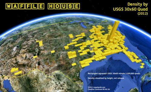
map
wafflehouse
density
usgs
atlanta
quad
geography
mapsbynik
8 images
korean peninsula
vintage map
antique map
cartography
historical map
traditional chinese
geography
old map
black and white
east asia
Mapnostic
2 images
volcano
bolivia
nature
geology
geography
fav
Satellite Delight
san francisco bay
satellite view
california
coastline
pacific ocean
aerial view
geography
earth observation
topography
landscape
Landsat
3 images
map
geography
internet
chart
data
tech
design
interactive
prosthetic knowledge
great lakes
satellite imagery
winter landscape
north america
snow cover
geography
aerial view
cloud cover
meteorology
earth observation
rachelbinx
maps
geography
europe
eurovision
Maps on the Web
navigation chart
aeronautical chart
cartography
map
north atlantic ocean
geography
maritime chart
atlas
topography
aviation
Scarpbook
map
south america
territorial dispute
maritime boundaries
ecuador
peru
chile
maritime claims
geopolitics
geography
STML
world map
map
geography
global distribution
coastal
marine
cartography
ocean
continents
data visualization
It is the business of the future to be dangerous.
sanfrancisco
bayarea
aerialphotography
geography
davidrumsey
Map Library
7 images
sea level rise
climate change
global warming
environmental science
geography
flooding
earth science
oceanography
maps
future earth
hyperreal cartography & the unrealized city
world map
travel restrictions
global mobility
passport power
visa-free travel
international travel
henley & partners
immigration
geography
travel infographic
Designed Conflict Territories
iraq
map
outline
minimalist
line art
geography
middle east
country
border
black and white
Tecznts
crater lake
topographic map
cartography
oregon
geography
wizard island
national park
contour lines
volcanic lake
map
Tecznts
alaska
map
united states
geography
infographic
north america
educational
demographics
climate
bering sea
Tupperwolf