notes.husk.org/likes
images.
tagged map.
page 2 of 4 with 93 images.
topography
data visualization
map
elevation
contour lines
united kingdom
digital art
cartography
abstract
geography
STML
united kingdom
map
icons
symbols
graphic design
typography
monochrome
uk
abstract
pictogram
Tecznts
boston
map
geography
landfill
hyperreal cartography & the unrealized city
planet
moon
earth
space
globe
map
grayscale
surreal
celestial
borders
STML
aerial view
satellite imagery
cityscape
urban landscape
map
architecture
urban planning
infrastructure
grid pattern
digital data
deathbeard
arctic
satellite imagery
map
geography
north pole
earth science
climate
cartography
weather
atmosphere
Dan W, Software Developer
map
london
datahacker
montreal
map
route
navigation
quebec
canada
street map
itinerary
path
geography
Internet of Dreams
map
water supply
california
watersheds
aqueducts
drinking water
environmental protection
hydrology
western united states
water resources
Advanced Methods for Geospatial Image Analysis
map
europe
network
connectivity
transportation
infrastructure
data visualization
logistics
routes
geography
mappeal
3 images
3d
webgl
map
data visualization
dataviz
maps
mapping
cartography
three.js
d3.js
javascript
data
visualization
nyc
js
art
datahacker
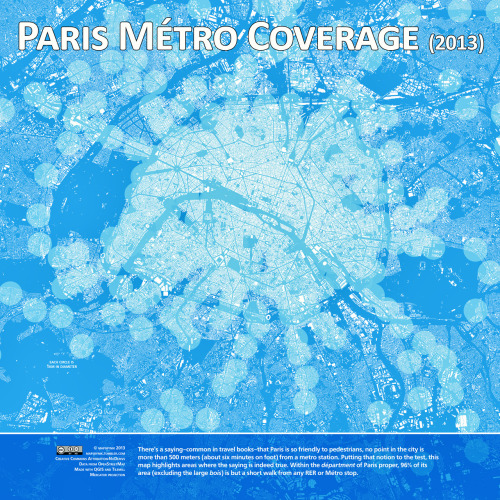
map
paris
metro
walkability
gis
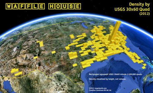
mapsbynik
map
wafflehouse
density
usgs
atlanta
quad
geography
mapsbynik
tech
internet
map
visualization
chart
reach
favicon
icon
logo
data
brand
brands
prosthetic knowledge
google maps
san francisco
fbi
federal bureau of investigation
map
navigation
screenshot
search results
california
street map
The New Aesthetic
map
cartography
urban design
city planning
graphic design
urbanism
abstract art
illustration
street map
urban landscape
Tecznts
infographic
data visualization
search trends
statistics
map
europe
ukraine
internet trends
global trends
top searches
STML
3 images
map
geography
internet
chart
data
tech
design
interactive
prosthetic knowledge
navigation chart
aeronautical chart
cartography
map
north atlantic ocean
geography
maritime chart
atlas
topography
aviation
Scarpbook
map
south america
territorial dispute
maritime boundaries
ecuador
peru
chile
maritime claims
geopolitics
geography
STML
world map
map
geography
global distribution
coastal
marine
cartography
ocean
continents
data visualization
It is the business of the future to be dangerous.
flight paths
data visualization
aviation
map
flight tracking
air routes
global mapping
geospatial data
infographic
travel patterns
One Visible Future
map
london
metropolitan police
history
Frankie Roberto
map
united states
traffic
highway
roads
navigation
midwest
us map
congestion
transportation
The New Aesthetic